Arlington's 10 planned areas, Rosslyn to East Falls Church, span three high school zones. Zillow's typical Arlington value: $801,809 in September 2026.
Last checked Oct. 19, 2026. The areas on this page are Arlington County’s own planning areas, from its Planning Areas map layer, plus the Arlington-East Falls Church area from the county’s civic association map layer. School zones come from the boundaries behind Arlington Public Schools’ boundary locator; ZIP codes from the Census Bureau’s ZIP Code Tabulation Areas; home values from the Zillow Home Value Index (Zillow Research); place names from OpenStreetMap (© OpenStreetMap contributors); population from the Census Bureau’s QuickFacts.
Arlington is a county of 236,254 people across the Potomac River from Washington, with no city or town inside it. The county has grown around its Metrorail stations and plans each station area and main road separately. Its four planning corridors are Rosslyn-Ballston, Richmond Highway (Crystal City and Pentagon City), Columbia Pike and Langston Boulevard. Between them lie single-family neighborhoods, which the county maps as 61 civic association areas. This guide covers 10 areas with a page each.
What this means for you
- Three neighborhood high schools: Wakefield, Washington-Liberty and Yorktown, by address
- Typical home value, Arlington: $801,809 in September 2026, according to Zillow
- Interstates: I-66 across North Arlington, I-395 across the southeast corner
- Zone questions: Arlington Public Schools, 703-228-8000
How Arlington is laid out
- One government. Arlington County collects the property tax, runs the police and collects the trash for every address; there is no city layer. Nearby “Falls Church” and “Alexandria” mailing addresses, though, are often in Fairfax County. Our comparison with Falls Church, Alexandria and Washington sets out the differences.
- ZIP codes. Eleven ZIP codes have at least a tenth of their land in Arlington, by the Census Bureau’s count: 22201 to 22207, 22209, 22211, 22213 and 22214. Zillow publishes values for nine of them.
- The main roads. I-66 runs across North Arlington from Rosslyn to East Falls Church; I-395 crosses the southeast past the Pentagon and Pentagon City. Langston Boulevard (U.S. 29), Arlington Boulevard (U.S. 50), Wilson Boulevard, Columbia Pike (VA 244) and Glebe Road (VA 120) are the main surface roads.
- School zones do not follow planning areas. Courthouse, Columbia Pike and Langston Boulevard are each split between two high school zones, and most areas cross two or more elementary zones. Check every address in the APS boundary locator.
Map
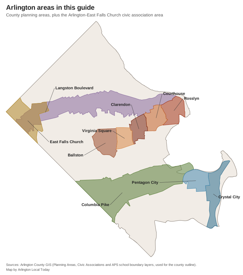
Map: Arlington Local Today, drawn from Arlington County’s GIS planning area, civic association and school boundary layers.
The areas at a glance
| Area | Main ZIP code | Zoned high school | Typical value, ZIP, September 2026 | Guide |
|---|---|---|---|---|
| Rosslyn | 22209 | Yorktown | $726,542 | Rosslyn |
| Courthouse | 22201 | Yorktown or Washington-Liberty | $699,223 | Courthouse |
| Clarendon | 22201 | Washington-Liberty | $699,223 | Clarendon |
| Virginia Square | 22201 and 22203 | Washington-Liberty | $699,223 and $642,144 | Virginia Square |
| Ballston | 22203 | Washington-Liberty | $642,144 | Ballston |
| Crystal City | 22202 | Wakefield | $733,336 | Crystal City |
| Pentagon City | 22202 | Wakefield | $733,336 | Pentagon City |
| Columbia Pike | 22204 | Wakefield or Washington-Liberty | $594,333 | Columbia Pike |
| Langston Boulevard | 22207 | Yorktown or Washington-Liberty | $1,365,085 | Langston Boulevard |
| East Falls Church | 22213 | Yorktown | $1,095,941 | East Falls Church |
The values are Zillow’s Home Value Index for each area’s main ZIP code, a modeled typical value for mid-priced homes, not a sale price. Our home prices guide has the county trend.
Rosslyn-Ballston corridor
Five Metro station areas run west from the Potomac along Wilson and Clarendon boulevards.
- Rosslyn: 288 acres of office and apartment towers by the Potomac, with Rosslyn station and the start of the Custis Trail. Zoned for Yorktown High.
- Courthouse: the county government center at 2100 Clarendon Blvd., apartment towers and townhouses, and the Saturday farmers market. Split between Yorktown and Washington-Liberty.
- Clarendon: restaurants, bars and shops around Clarendon station, with Lyon Village and Lyon Park around it. Zoned for Washington-Liberty.
- Virginia Square: George Mason University’s Arlington campus, Central Library and Quincy Park. Zoned for Washington-Liberty.
- Ballston: the largest of the five, with Ballston Wetland Park and seven ART routes. Zoned for Washington-Liberty.
Richmond Highway corridor
- Crystal City: high-rises along U.S. 1 between the Pentagon and Reagan National Airport, with 36-acre Long Bridge Park. Zoned for Wakefield High.
- Pentagon City: apartments, offices and shopping around Pentagon City station, under a sector plan re-adopted in July 2024. Zoned for Wakefield High.
South and North Arlington corridors
- Columbia Pike: the largest planning area, 1,689 acres of apartments, condominiums and single-family streets along a bus corridor with no Metro station. Split between Wakefield and Washington-Liberty.
- Langston Boulevard: the former Lee Highway, with Cherrydale, Halls Hill and the shopping strips along U.S. 29, under a plan adopted in November 2023. Split between Yorktown and Washington-Liberty.
- East Falls Church: a residential area around East Falls Church station on the line with the city of Falls Church, with the W&OD Trail. Zoned for Yorktown.
Areas without their own page yet
Most of Arlington is single-family neighborhoods outside the planning corridors, such as Westover, Fairlington, Shirlington, Arlington Ridge, Donaldson Run and Bluemont. The county’s civic association map shows the boundary of each, and our schools guide and parks and trails guide cover them.
How we built this
The areas are Arlington County’s own: the nine planning areas in its GIS Planning Areas layer, and, for East Falls Church, which has an adopted area plan but no planning-area polygon, the Arlington-East Falls Church civic association boundary. We measured each area’s share of ZIP codes against Census ZIP Code Tabulation Areas and its share of each school zone against the boundaries APS uses in its locator. School ratings are the Virginia Department of Education’s 2026-27 framework results. Parks come from the county’s parks layer, bus routes from Arlington Transit’s published schedule data, and stores, trails and road distances from OpenStreetMap. We do not rank areas.
How to check an address
Look up the parcel on the county’s property search, check the schools in the APS boundary locator, and see our property tax guide for the county rate and due dates.
Frequently asked questions
What are the neighborhoods of Arlington, Virginia?
The county plans its growth around four corridors: Rosslyn-Ballston (Rosslyn, Courthouse, Clarendon, Virginia Square and Ballston), Richmond Highway (Crystal City and Pentagon City), Columbia Pike and Langston Boulevard. Around them, the county’s map shows 61 civic association areas, such as Lyon Village, Cherrydale, Westover, Fairlington and East Falls Church.
What ZIP codes are in Arlington, Virginia?
The Census Bureau counts 11 ZIP codes with at least a tenth of their land in Arlington: 22201, 22202, 22203, 22204, 22205, 22206, 22207, 22209, 22211, 22213 and 22214.
How many high schools does Arlington have?
Arlington Public Schools has three neighborhood high schools: Wakefield, Washington-Liberty and Yorktown. Which one serves a home depends on the address, and several areas are split between zones.
What is the typical home value in Arlington?
Zillow’s Home Value Index put Arlington at $801,809 in September 2026, up 1.3% from a year earlier. By ZIP code it ranged from $545,500 in 22206 to $1,365,085 in 22207. These are modeled values, not sale prices.
Have your say