Arlington began as Alexandria County in the District of Columbia in 1801, returned to Virginia in 1847 and took its name in 1920. 67 National Register sites.
Last checked Oct. 19, 2026. Facts on this page come from the Arlington Historical Society’s Historical Milestones and Plan Your Visit pages, Arlington County’s historic places and National Historic Places pages, the National Park Service’s National Register spreadsheet (listings to May 22, 2026) and Arlington National Cemetery.
Arlington was never founded as a town. The land became Alexandria County, part of the new District of Columbia, under the Organic Act of 1801, was returned to Virginia in 1847, lost the City of Alexandria in 1870 and was renamed Arlington County in 1920, according to the Arlington Historical Society. It has never incorporated a city, so the county is the community. Questions about historic districts and markers go to the county’s Historic Preservation Program, 703-228-3549.
Visit
- Arlington Historical Museum, Hume School, 1805 S. Arlington Ridge Road: Saturdays 10 a.m. to 4 p.m., Sundays 1 to 4 p.m. Free admission and parking.
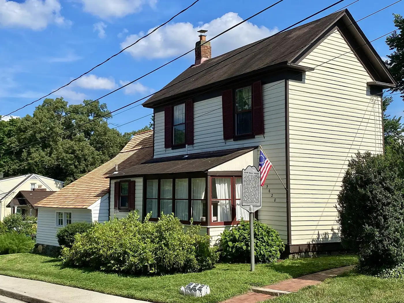
- Ball-Sellers House, 5620 S. 3rd St.: Saturdays 1 to 4 p.m., April through October. Free guided tours.
- Arlington National Cemetery: open daily 8 a.m. to 5 p.m.; 877-907-8585.
How Arlington came to be
The Arlington Historical Society’s timeline of milestones:
| Year | Milestone |
|---|---|
| 1608 | Capt. John Smith travels up the Potomac River to Arlington. |
| 1719 | Thomas, the 6th Lord Fairfax, inherits the Northern Neck Proprietary, which included Arlington. |
| 1750 | Farmer John Ball builds the Ball-Sellers House. |
| 1790 | The Residence Act sets aside a 100-square-mile federal capital that takes in present-day Arlington. |
| 1797 | The first bridge across the Potomac in the area is built near Little Falls; its successor becomes known as Chain Bridge. |
| 1801 | The District of Columbia Organic Act creates Washington County and Alexandria County. |
| 1802 | George Washington Parke Custis names his estate “Arlington.” |
| 1814 | The Declaration of Independence is hidden in a grist mill at Pimmit Run during the War of 1812. |
| 1831 | Mary Anna Randolph Custis marries Robert E. Lee; they live on the Arlington estate. |
| 1847 | Alexandria County is retroceded to Virginia. |
| 1864 | Arlington National Cemetery is created on the former Lee estate. |
| 1870 | The City of Alexandria separates from Alexandria County. |
| 1920 | Alexandria County is renamed Arlington County. |
| 1925 | Washington-Lee High School, now Washington-Liberty, opens with about 600 students. |
| 1935 | Construction begins on Colonial Village, one of the nation’s first garden-apartment complexes. |
| 1943 | The Pentagon is completed. |
| 1956 | The Arlington Historical Society is founded and campaigns to save the Hume School. |
| 1959 | Stratford Junior High becomes the first Arlington school to integrate. |
| 1976 | Metro opens with stops in Arlington, and the first Marine Corps Marathon starts at the Iwo Jima Memorial. |
Museums and sites to visit
- Arlington Historical Museum. Housed in the Hume School, the oldest surviving school building in the county, named for Frank Hume, who donated the land. Exhibits run from Arlington’s Indigenous peoples and enslaved residents through the Civil War, transportation, World War II, immigration and 9/11, including “First on the Scene,” on Arlington’s response to the attack on the Pentagon. Visitors can ring the old school bell.
- Ball-Sellers House. The c. 1750 farmhouse, the oldest structure in Arlington, with period furnishings and colonial-style gardens. Free guided tours on Saturday afternoons in season.
- Arlington National Cemetery and Arlington House, the Robert E. Lee Memorial, on the former Custis-Lee estate. The cemetery is open daily 8 a.m. to 5 p.m.
- Charles Richard Drew House, 2505 1st St. S. The family home of the physician whose research on blood transfusions led to the American Red Cross Blood Bank, the society says. It was listed on the National Register in 1976.
- Historical markers. More than 80 markers around the county, from Civil War forts to ARPANET and the parking garage where Watergate source Deep Throat met reporter Bob Woodward, the county says. The county keeps a list of historical markers.
Historic districts
Arlington designates its own local historic districts, including Fort Ethan Allen, Glebe House, Green Valley Pharmacy, Hume School and Calloway Cemetery. Changes to buildings in them need a Certificate of Appropriateness from the Historical Affairs and Landmark Review Board. A 2011 county survey identified nearly 400 historic garden apartments, shopping centers and commercial buildings built before 1955.
National Register of Historic Places listings
The county says Arlington has more than 70 historic buildings, sites and neighborhoods on the National Register. The National Park Service’s spreadsheet lists the following properties in Arlington County, by the year each was listed. (Federal landmarks the county also counts, such as Arlington Memorial Bridge, Key Bridge and the George Washington Memorial Parkway, are filed under other jurisdictions in the federal list.)
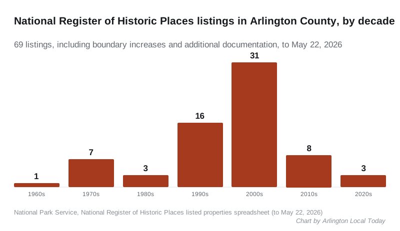
Most of Arlington’s listings are 20th-century neighborhoods and garden-apartment complexes listed since the late 1990s.
| Year listed | Property | Location |
|---|---|---|
| 1966 | Arlington House, The Robert E. Lee Memorial | Arlington National Cemetery |
| 1972 | The Glebe | 4527 17th St., N. |
| 1972 | Fort Myer Historic District | Arlington Blvd. (U.S. 50) |
| 1972 | Quarters 1, Fort Myer | Grant Ave. |
| 1975 | Ball-Sellers House | 5620 S. 3rd St. |
| 1976 | Benjamin Banneker SW 9 Intermediate Boundary Stone | 18th and Van Buren Sts. |
| 1976 | Charles Richard Drew House | 2505 1st St., S. |
| 1979 | Hume School | 1805 S. Arlington Ridge Rd. |
| 1980 | Colonial Village | Roughly bounded by Wilson Blvd., Lee Hwy., N. Veitch St. and Queens Lane |
| 1986 | U.S. Post Office, Arlington | 3118 N. Washington Blvd. |
| 1989 | The Pentagon (additional documentation) | Washington Blvd. (VA 27), Richmond Hwy. (VA 110), Shirley Hwy. (I 395) |
| 1991 | Northwest No. 1 Boundary Marker of the Original District of Columbia | 3607 Powhatan St. |
| 1991 | Northwest No. 2 Boundary Marker of the Original District of Columbia | 5145 N. 38th St. |
| 1991 | Southwest No. 4 Boundary Marker of the Original District of Columbia | King St. N of jct. with Wakefield St. |
| 1991 | Southwest No. 5 Boundary Marker of the Original District of Columbia | NE of jct. of King St. and Walter Reed Dr. |
| 1991 | Southwest No. 6 Boundary Marker of the Original District of Columbia | S. Jefferson St. S of jct. with Columbia Pike, in median strip |
| 1991 | Southwest No. 7 Boundary Marker of the Original District of Columbia | Behind 3101 S. Manchester St. |
| 1991 | Southwest No. 8 Boundary Marker of the Original District of Columbia | Jct. of Wilson Blvd. and John Marshall Dr., behind apt. bldg. |
| 1991 | West Cornerstone | W side Meridian St., S of jct. with Williamsburg Blvd. |
| 1993 | Carlin Hall | 5711 4th St., S. |
| 1995 | Barcroft Community House | 800 S. Buchanan St. |
| 1995 | Cherrydale Volunteer Fire House | 3900 N. Lee Hwy. |
| 1997 | Washington National Airport Terminal and South Hangar Line | Thomas Ave. |
| 1997 | Calvert Manor | 1925-1927 N. Calvert St. |
| 1999 | Buckingham Historic District (boundary increases 2004 and 2010) | Roughly bounded by N. 5th, N. Oxford, and N. 2nd Sts., and N. Glebe Rd. |
| 1999 | Fairlington Historic District | Roughly bounded by Quaker Lane, King St., I-395, S. Walter Reed Dr., and S. Abingdon St. |
| 1999 | Clarendon School | 3550 Wilson Blvd. |
| 2000 | Fort C. F. Smith Historic District | 2411 24th St. |
| 2002 | Lyon Village Historic District | Roughly bounded by Lee Hwy, N. Veitch St., N. Franklin Rd., N. Highland St., N. Fillmore St., and N. Kirkwood Rd. |
| 2003 | Arlington Village Historic District | S 13th St., S 13 Rd., S 16th St., S Barton S., S. Cleveland St. and Edgewood St. |
| 2003 | Cherrydale Historic District | Roughly bounded by Lorcom Ln., N. Utah and N. Taylor Sts., and I-66 |
| 2003 | George Crossman House | 2501 N. Underwood St. |
| 2003 | Maywood Historic District | Roughly bounded by Lorcom Ln., Spout Run Parkway, I-66, Lee Highway, N. Oakland St., N. Nelson St., and N. Lincoln St. |
| 2003 | Saegmuller House | 5101 Little Falls Rd. |
| 2003 | Walter Reed Gardens Historic District | 2900-2906 13th St. S, 2900-2914 13th Rd S, 1301-1319 S. Walter Reed Dr. |
| 2003 | Ashton Heights Historic District | Roughly bounded by Wilson Blvd., N. Irving St., Arlington Blvd., N. Oxford St., N. Piedmont & N. Oakland Sts. |
| 2003 | Al’s Motors | 3910 Wilson Blvd. |
| 2003 | Lyon Park Historic District | Roughly bounded by 10th St. N, Arlington Blvd., and N. Irving St. |
| 2004 | Columbia Forest Historic District | Bounded by 11th, S. Edison, S. Dinwiddie, S. Columbus, S. George Mason, and S. Frederick St. |
| 2004 | Fort Ethan Allen | Address restricted |
| 2004 | Glebe Center | 71-89 N. Glebe Rd. |
| 2004 | Glebewood Village Historic District | N. Brandywine St. Bet. Lee Hwy and 10th Place N, 21St Rd. bet. N. Brandywine St. and N. Glebe Rd. |
| 2004 | Harry W. Gray House | 1005 S. Quinn St. |
| 2004 | Lomax African Methodist Episcopal Zion Church | 2704 24th Rd. S |
| 2004 | Lee Gardens North Historic District | 2300-2341 N. 11th St. |
| 2004 | Stratford Junior High School | 4100 Vacation Ln. |
| 2004 | Waverly Hills Historic District | Roughly bounded by 20th Rd. N, N. Utah St, I-66, N. Glebe Rd. and N. Vermont St. |
| 2004 | Penrose Historic District | Roughly bounded by Arlington Blvd., S. Courthouse Rd., S. Fillmore St., S. Barton St. S, and Columbia Pike |
| 2005 | Arlington Forest Historic District | Bounded by Carlin Springs Rd., George Mason Dr., Henderson Rd., Aberdeen St., Columbus St., Granada, Galveston and 2nd |
| 2006 | Westover Historic District | Bounded by McKinley Rd., N. Washington Blvd., N. 16th St., N. Jefferson St., N. 11th St. and N. Fairfax Dr. |
| 2006 | Claremont Historic District | Bounded by S. Dinwiddie St., S. Chesterfield Rd., S. Buchanan St., 25th St. S, 24th St. S, 23rd St. S and 22nd St. S |
| 2008 | Arlington Heights Historic District | Bounded by Arlington Blvd., S. Fillmore St., S. Walter Reed Dr., Columbia Pk., & S. Glebe Rd. |
| 2008 | Monroe Courts Historic District | 1041-1067 N. Nelson and 1036-1062 & 1033-1055 N. Monroe Sts. |
| 2008 | Virginia Heights Historic District | Bounded by 10th Pl. S., S. Frederick St. & S. George Mason Dr. |
| 2008 | Glencarlyn Historic District | Bounded by S. Carlin Springs Rd., Arlington Blvd., 5th Rd. S., Glencarlyn Park |
| 2008 | Aurora Highlands Historic District | Bounded by 16th St. S., S. Eads St., 26th St. S., and S. Joyce St. |
| 2009 | Arlington Ridge Park | NW corner of N. Meade St. and Marshall Dr. |
| 2011 | Earle Micajah Winslow House | 2333 N Vernon St |
| 2011 | Highland Park-Overlee Knolls | Roughly bounded by 22nd St. N., N. Lexington St., 16th St. N., N. Longfellow St., McKinley Rd., I-66 & N. Quantico St. |
| 2012 | Dominion Hills Historic District | Roughly bounded by N. Four Mile Run Dr., N. McKinley Rd., N. Larrimore, N. Madison, N. Montana Sts., & 9th St. N. |
| 2012 | Georgetown Pike | From DC/VA boundary at Chain Bridge to jct. with Leesburg Pike at Seneca Rd. |
| 2014 | Arlington House Historic District | Roughly bounded by Sheridan, Humphreys, Ord & Weitzel Drs., Lee Ave. |
| 2014 | Arlington National Cemetery Historic District | 1 Memorial Ave. |
| 2014 | Unitarian Universalist Church of Arlington | 4444 Arlington Blvd. |
| 2020 | Glebe Apartments | 210-212 North Glebe Rd. |
| 2021 | Windsor Apartments | 20-204 North Thomas St. |
| 2023 | The Pentagon (boundary increase) | Washington Blvd. (VA 27), Richmond Hwy. (VA 110), Shirley Hwy. (I 395) |
| Addresses are as the National Park Service records them. Most listed properties are private homes, | ||
| apartments or businesses; respect owners’ privacy. |
Related guides: Arlington population and growth, parks and trails and getting around Arlington.
Frequently asked questions
When was Arlington County founded?
The land became Alexandria County, part of the District of Columbia, under the Organic Act of 1801. It was returned to Virginia in 1847, the City of Alexandria separated in 1870, and the county was renamed Arlington County in 1920, according to the Arlington Historical Society.
Why is it called Arlington?
George Washington Parke Custis, step-grandson of George Washington, named his estate Arlington in 1802. Alexandria County took the name Arlington County in 1920.
What is the oldest building in Arlington?
The Ball-Sellers House at 5620 S. 3rd St., a farmhouse built about 1750, is the oldest structure in the county, the Arlington Historical Society says. It is open free on Saturdays, 1 to 4 p.m., April through October.
Where is the Arlington Historical Museum?
In the Hume School, 1805 S. Arlington Ridge Road, the oldest surviving school building in Arlington. It is open Saturdays 10 a.m. to 4 p.m. and Sundays 1 to 4 p.m.; admission and parking are free.
How many National Register sites are in Arlington?
The National Park Service lists 67 Arlington County properties and districts on the National Register of Historic Places, from Arlington House (1966) to the Windsor Apartments (2021).
Have your say